The Invisible Map: How Drones “See” the World Without GPS
When GPS drops out — inside a tunnel, under thick tree cover, or during solar interference — a drone doesn’t just freeze midair. Modern autonomous drones are equipped with systems that let them “see” and interpret their surroundings, even when satellite signals vanish. This ability isn’t magic; it’s built on a complex fusion of sensors and algorithms that reconstruct a 3D understanding of space in real time.
Imagine you’re walking through your apartment in the dark. You don’t need to see the walls; you rely on memory and spatial cues. Drones do something similar: they create an internal map of the world as they move. That internal “map” helps them track their own motion, avoid obstacles, and maintain orientation — all without a single satellite ping.
“A drone without GPS is like a person without eyesight — until you give it new senses,” says Dr. Maria Varga, an AI robotics researcher at ETH Zurich.
Visual Odometry and SLAM — Teaching Machines Spatial Awareness
The backbone of GPS-free navigation lies in techniques called visual odometry and SLAM (Simultaneous Localization and Mapping). These methods let drones use onboard cameras to analyze how their environment changes as they move. Essentially, they calculate position by comparing consecutive images — like a stop-motion movie, but in reverse.
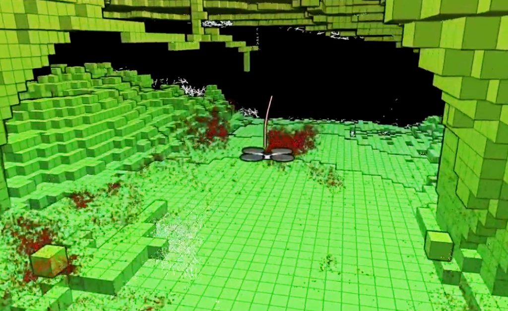
SLAM goes a step further: it builds a dynamic map of the world while figuring out where the drone is inside that map. It’s a bit like a hiker drawing a map while still walking through an unknown forest. The algorithm constantly updates as the drone flies, adjusting for drift, lighting, or motion blur. This is what allows a drone to move confidently even when it’s never “seen” the place before.
These systems are already used in self-driving cars, Mars rovers, and warehouse robots. The principle is universal: perception replaces positioning.
The Power of Sensors: From LiDAR to IMUs
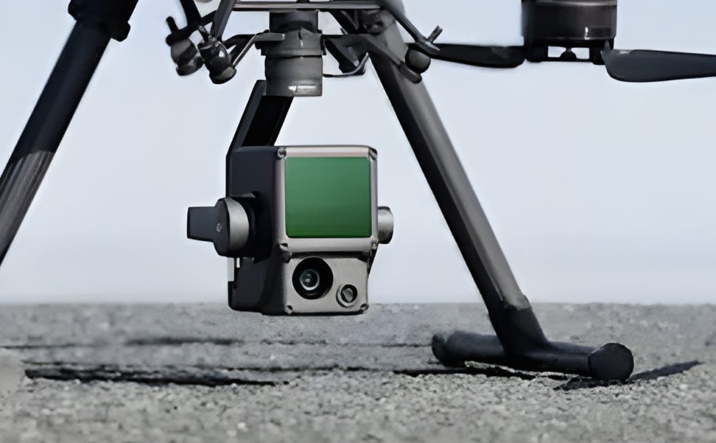
While cameras provide vision, drones need more than eyes. That’s where a symphony of sensors comes in — LiDAR for depth, ultrasonic sensors for proximity, and IMUs (Inertial Measurement Units) for orientation. Together, they give the drone a sense of motion and gravity. If a gust of wind pushes it off course, the IMU instantly detects the shift, and the flight controller corrects it in milliseconds.
LiDAR — the same laser-based tech used in autonomous vehicles — sweeps the environment with invisible light pulses, creating detailed 3D point clouds. Combined with visual odometry, LiDAR helps drones understand both texture and distance. When GPS isn’t an option, this depth perception becomes essential for landing safely or navigating tight indoor spaces.
Some advanced systems also integrate radar and infrared imaging, which can “see” through fog, dust, or smoke — conditions where GPS and cameras both struggle.
When the Sky Gets Tricky — How Drones Handle Obstacles and Weather
GPS isn’t just about navigation; it also helps with stabilization and coordination in fleets. Without it, drones must rely on their own perception to avoid collisions and maintain balance. To achieve this, many models use AI-powered obstacle detection that predicts movement rather than just reacting to it. It’s a major leap — from being guided by satellites to acting like self-aware agents.
Weather adds another layer of challenge. In strong winds or low visibility, drones cross-reference input from sensors to maintain flight stability. Some even use barometric pressure sensors to gauge altitude when optical methods fail. The goal is resilience — being able to fly where traditional navigation fails, like under bridges, in caves, or near skyscrapers where GPS signals bounce unpredictably.
In tests by MIT’s AeroAstro lab, drones using visual-inertial SLAM completed indoor obstacle courses with 94% accuracy — without any GPS data at all.
Real-World Applications: From Delivery to Disaster Zones
GPS-free navigation isn’t just a technical trick; it’s a necessity in many industries. For example, delivery drones in dense urban areas often lose GPS signals due to signal reflection — a phenomenon known as “multipath.” Systems like visual SLAM allow them to complete routes autonomously. In search-and-rescue missions, drones can enter collapsed buildings and navigate through debris using visual and depth cues.
Mining, agriculture, and military operations also benefit. In underground tunnels or remote canyons, traditional GPS is useless. Companies like Skydio and DJI are leading in visual navigation, enabling drones to inspect power lines, bridges, and pipelines without external positioning. What once required a full satellite network can now be done with onboard intelligence.
What’s Next: Learning Navigation from Nature
Researchers are now taking cues from birds and insects. Bees, for instance, use visual flow — the speed of passing scenery — to estimate distance. Birds rely on magnetic fields and environmental landmarks. Some experimental drones already mimic these biological cues, blending AI vision with “neuromorphic” chips that process data like animal brains do: fast, adaptive, and energy-efficient.
In the near future, drones may navigate the world the way humans do — with intuition built from experience. When GPS is unavailable, they’ll rely on a mix of memory, perception, and learning. The line between machine and organism will blur just a little more — and the sky will get smarter.